
Longs Peak OnlineTrail Map
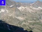
At 14,255 feet, Longs Peak towers above all other summits in Rocky Mountain National Park. The summer is the only season in which the peak can be climbed by a non-technical route. Early mornings break calm, clouds build in the afternoon sky, often exploding in storms of brief, heavy rain, thunder and dangerous lightning. Begin your hike early, way before dawn, to be back below timberline before the weather turns for the worse.
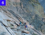
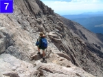
The Keyhole Route, Longs Peak's only non-technical hiking pathway, is a 16 mile round trip with an elevation gain of 4,850 feet. Though non-technical, the Keyhole Route is still challenging and is not recommended for those who are afraid of heights or exposed ledges. Hikers should be properly outfitted with clothing, food and water. Use caution when ascending or descending steep areas. Don't be afraid to back down when bad weather threatens.